Mariana Trench

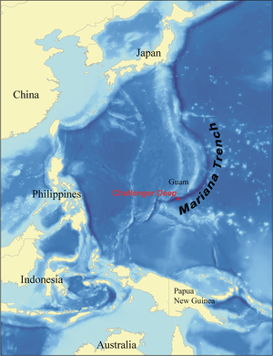
The Mariana Trench is the deepest part of the world's oceans, and the lowest elevation of the surface of the Earth's crust. It is located in the western Pacific Ocean, to the east of the Mariana Islands. The trench is about 2,550 kilometres (1,580 mi) long but has a mean width of only 69 kilometres (43 mi). It reaches a maximum-known depth of about 11.03 kilometres (6.85 mi) at the Vityaz-1 Deep and about 10.91 kilometres (6.78 mi) at the Challenger Deep, a small slot-shaped valley in its floor, at its southern end.[1] If Mount Everest, the highest mountain on Earth at 8,848 metres (29,029 ft), were set in the deepest part of the Mariana Trench, there would be 2,076 metres (6,811 ft) of water left above it.[2]
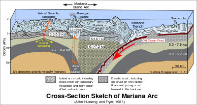
Part of the Izu-Bonin-Mariana Arc system trenches forms the boundary between two tectonic plates, where the western edge of the Pacific Plate is subducted beneath the small Mariana Plate. Because the Pacific plate is the largest of all the tectonic plates on Earth, crustal material at its western edge has had a long time since formation (up to 170 million years) to compact and become very dense; hence its great height-difference relative to the higher-riding Mariana Plate, at the point where the Pacific Plate crust is subducted. This deep area is the Mariana trench proper. The movement of these plates is also responsible for the formation of the Mariana Islands.
At the bottom of the trench, where the plates meet, the water column above exerts a pressure of 108.6 megapascals (15,750 psi), over one thousand times the standard atmospheric pressure at sea level.
Because the Earth is not a perfect sphere, the trench is not the part of the seafloor closest to the center of the Earth - parts of the Arctic Ocean seabed are at least 13,000 metres closer to the center than the Challenger Deep seafloor.
Contents |
Measurements

The trench was first sounded during the Challenger expedition (December 1872 – May 1876), which recorded a depth of 4,475 fathoms, 8,184 m (26,850 feet). In 1877 a map was published called Tiefenkarte des Grossen Oceans by Petermann, which showed a Challenger Tief at the location of that sounding. In 1899 USS Nero, a converted collier, recorded a depth of 5269 fathoms (9,636 m, 31,614 ft).[3]
Challenger II surveyed the trench using echo sounding, a much more precise and vastly easier way to measure depth than the sounding equipment and drag lines used in the original expedition. During this survey, the deepest part of the trench was recorded when the Challenger II measured a depth of 5,960 fathoms (10,900 m, 35,760 ft) at ,[4] known as the Challenger Deep.[2]
In 1957, the Soviet vessel Vityaz reported a depth of 11,034 m (36,201 ft), dubbed the Mariana Hollow.[5]
In 1962, the surface ship M.V. Spencer F. Baird recorded a maximum depth of 10,915 m (35,840 ft), using precision depth gauges.[4]
In 1984, the Japanese sent the Takuyō (拓洋), a highly specialized survey vessel, to the Mariana Trench and collected data using a narrow, multi-beam echo sounder; they reported a maximum depth of 10,924 m, also reported as 10,920 metres ± 10 metres.[4][6]
On 1 June 2009 sonar mapping of the Challenger Deep by the Simrad EM120 sonar multibeam bathymetry system for deep water (300 - 11,000 m) mapping aboard the RV Kilo Moana (mothership of the Nereus vehicle), has indicated a spot with a depth of 10,971 m (35,994 ft). The sonar system uses phase and amplitude bottom detection, with an accuracy of better than 0.2% of water depth across the entire swath (implying the depth figure is accurate to less than ± 11 metres).[7][8]
In 2003, a spot was found along the Mariana Trench, the depth of which is around the same depth as the Challenger Deep, possibly even deeper. It was discovered while scientists from the Hawaii Institute of Geophysics and Planetology were completing a survey around Guam; they used a sonar mapping system towed behind the research ship to conduct the survey. This new spot was named the HMRG (Hawaii Mapping Research Group) Deep, after the group of scientists who discovered it.[9]
Descents
.jpeg)
The Swiss-designed, Italian-built, United States Navy bathyscaphe Trieste reached the bottom at 1:06 p.m. on January 23, 1960, with U.S. Navy Lieutenant Don Walsh and Jacques Piccard on board.[2] Iron shot was used for ballast, with gasoline for buoyancy.[2] The onboard systems indicated a depth of 11,521 m (37,799 ft), but this was later revised to 10,916 m (35,814 ft).[10] At the bottom, Walsh and Piccard were surprised to discover sole or flounder about 30 cm (1 ft) long,[10] as well as a shrimp.[1] According to Piccard, "The bottom appeared light and clear, a waste of firm diatomaceous ooze".[10]
Only three descents have ever been achieved. The first was the manned descent by Trieste in 1960. This was followed by the unmanned ROVs Kaikō in 1995 and Nereus in 2009. These three expeditions directly measured very similar depths of 10,902 to 10,916 m.
See also
- Izu-Ogasawara Trench
- Oceanic trench
- Philippine Trench (including the Mindanao Deep, similar to the Challenger Deep)
- Mid-ocean ridge
- Yap Trench
Notes
- ↑ "NOAA Ocean Explorer: History: Quotations: Soundings, Sea-Bottom, and Geophysics". NOAA, Office of Ocean Exploration and Research. http://www.marianatrench.com/mariana_trench-oceanography.htm.
- ↑ 2.0 2.1 2.2 2.3 "The Mariana Trench - Oceanography". marianatrench.com. http://www.marianatrench.com/mariana_trench-oceanography.htm.
- ↑ Theberge, A. (24 March 2009). "Thirty Years of Discovering the Mariana Trench". Hydro International. http://www.hydro-international.com/issues/articles/id1049-Thirty_Years_of_Discovering_the_Mariana_Trench.html. Retrieved 31 July 2010.
- ↑ 4.0 4.1 4.2 Ritchie, Steve. "The deepest depths". http://www.noc.soton.ac.uk/OTHERS/CSMS/OCHAL/deep.htm.
- ↑ "Mariana Trench". Encyclopedia Britannica. Encyclopedia Britannica.
- ↑ "New Chief Hydrographer of Japan". http://www1.kaiho.mlit.go.jp/GIJUTSUKOKUSAI/ICO/nl45.html.
- ↑ "Daily Reports for R/V KILO MOANA June and July 2009". University of Hawaii Marine Center. http://www.soest.hawaii.edu/UMC/Reports/Archives/KMreportJuneJuly2009.html.
- ↑ "Inventory of Scientific Equipment aboard the R/V KILO MOANA". University of Hawaii Marine Center. http://www.soest.hawaii.edu/UMC/KM/scienceequipment.htm.
- ↑ Whitehouse, David. "Sea floor survey reveals deep hole". BBC News. http://news.bbc.co.uk/2/hi/science/nature/3071749.stm.
- ↑ 10.0 10.1 10.2 National Oceanic and Atmospheric Administration (NOAA) webpage. Section "1960 - Man at the Deepest Depth"
External links
- Ocean Explorer (http://www.oceanexplorer.noaa.gov) - Public outreach site for explorations sponsored by NOAA's Office of Ocean Exploration & Research.
- NOAA, Ocean Explorer Mariana Arc - A rich collection of images, video, audio and podcast.
- NOAA, Ocean Explorer YouTube Ring of Fire Explorations Playlist 2004-2006
- NOAA, Ocean Explorer Google Map
- Mariana Trench on maps.google.com
- The Mariana Trench to scale
|
|||||||||||||||||